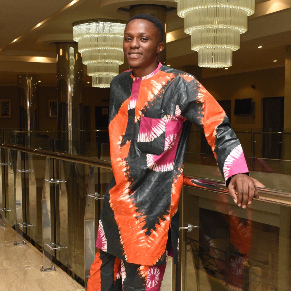
Oluwadare JamesAI/ML, Geospatial & UAV Engineer
Machine Learning · Drone Engineering · Geospatial Intelligence
I'm a data scientist and drone engineer building AI, software and unmanned aerial systems. With a background in Mechanical Engineering (Aeronautics), I work across UAV design, machine learning and geospatial intelligence to turn field data into decisions. I'm Head of drone engineering & design at Hoverfleet and founder of AeroHub.
Selected work & expertise
Tech stack
Languages
- Python
- JavaScript
 QML
 MATLAB
 Arduino
Frameworks & Libraries
- Qt
- FastAPI
- Matplotlib
- PyTorch
%20--%3e%3csvg%20version='1.1'%20id='Layer_1'%20xmlns='http://www.w3.org/2000/svg'%20xmlns:xlink='http://www.w3.org/1999/xlink'%20x='0px'%20y='0px'%20viewBox='0%200%201080%201080'%20style='enable-background:new%200%200%201080%201080;'%20xml:space='preserve'%3e%3cstyle%20type='text/css'%3e%20.st0{fill:%23FFFFFF;}%20.st1{fill:%23D00000;}%20%3c/style%3e%3cg%3e%3cpath%20class='st0'%20d='M1080,1079.96c0,0.02-0.02,0.04-0.04,0.04H0.04c-0.02,0-0.04-0.02-0.04-0.04V0.04C0,0.02,0.02,0,0.04,0%20h1079.93c0.02,0,0.04,0.02,0.04,0.04V1079.96z'/%3e%3c/g%3e%3cg%3e%3cpath%20class='st1'%20d='M1062,1061.96c0,0.02-0.02,0.04-0.04,0.04H18.04c-0.02,0-0.04-0.02-0.04-0.04V18.04%20c0-0.02,0.02-0.04,0.04-0.04h1043.93c0.02,0,0.04,0.02,0.04,0.04V1061.96z'/%3e%3c/g%3e%3cg%3e%3cpath%20class='st0'%20d='M303,823.67c0,0.79,0.46,1.89,1.01,2.44l17.87,17.87c0.56,0.56,1.66,1.01,2.44,1.01h61.15%20c0.79,0,1.89-0.46,2.44-1.01l17.87-17.87c0.56-0.56,1.01-1.66,1.01-2.44V629.64c0-0.79,0.47-1.88,1.04-2.42l77.69-74.2%20c0.57-0.54,1.4-0.46,1.84,0.2l196.29,290.6c0.44,0.65,1.45,1.19,2.23,1.19h86.63c0.79,0,1.73-0.57,2.09-1.27l15.72-30.46%20c0.36-0.7,0.29-1.8-0.16-2.45L560.56,478.03c-0.45-0.65-0.36-1.63,0.2-2.19l211.18-210.19c0.56-0.56,1.01-1.65,1.01-2.44v-3.88%20c0-0.79-0.26-2.02-0.57-2.75l-12.18-28.01c-0.31-0.72-1.22-1.31-2-1.31h-85.63c-0.79,0-1.89,0.46-2.44,1.01l-262.31,263.3%20c-0.56,0.56-1.01,0.37-1.01-0.42V249.6c0-0.79-0.44-1.9-0.98-2.48l-17.53-18.8c-0.54-0.58-1.62-1.05-2.41-1.05h-61.57%20c-0.79,0-1.87,0.47-2.41,1.05l-17.95,19.38c-0.54,0.58-0.97,1.69-0.97,2.48V823.67z'/%3e%3c/g%3e%3c/svg%3e) Keras
;}.cls-3{fill:url(%23linear-gradient);}.cls-4{clip-path:url(%23clip-path-2);}.cls-5{fill:url(%23linear-gradient-2);}.cls-6{fill:%23425066;}%3c/style%3e%3cclipPath%20id='clip-path'%3e%3cpolygon%20class='cls-1'%20points='402%20112.59%20337.47%2075.72%20337.47%20226.84%20363.25%20211.88%20363.25%20169.36%20382.72%20180.63%20382.61%20151.54%20363.25%20140.48%20363.25%20123.59%20402.09%20146.03%20402%20112.59'/%3e%3c/clipPath%3e%3clinearGradient%20id='linear-gradient'%20x1='261.18'%20y1='151.1'%20x2='419.65'%20y2='151.1'%20gradientUnits='userSpaceOnUse'%3e%3cstop%20offset='0'%20stop-color='%23ff6f00'/%3e%3cstop%20offset='1'%20stop-color='%23ffa800'/%3e%3c/linearGradient%3e%3cclipPath%20id='clip-path-2'%3e%3cpolygon%20class='cls-1'%20points='267.14%20112.59%20331.67%2075.72%20331.67%20226.84%20305.89%20211.88%20305.89%20123.59%20267.05%20146.03%20267.14%20112.59'/%3e%3c/clipPath%3e%3clinearGradient%20id='linear-gradient-2'%20x1='260.11'%20y1='151.1'%20x2='418.58'%20y2='151.1'%20xlink:href='%23linear-gradient'/%3e%3c/defs%3e%3ctitle%3eFullColorPrimary%20Vertical%3c/title%3e%3cg%20class='cls-2'%3e%3crect%20class='cls-3'%20x='261.18'%20y='75.17'%20width='158.47'%20height='151.86'/%3e%3c/g%3e%3cg%20class='cls-4'%3e%3crect%20class='cls-5'%20x='260.11'%20y='75.17'%20width='158.47'%20height='151.86'/%3e%3c/g%3e%3cpath%20class='cls-6'%20d='M137.32,287.6H114v64.23H101.15V287.6H78.07V277.14h59.25Z'/%3e%3cpath%20class='cls-6'%20d='M152.77,352.85q-11.85,0-19.21-7.46t-7.36-19.88V324a33.4,33.4,0,0,1,3.2-14.85,24.4,24.4,0,0,1,9-10.18,23.76,23.76,0,0,1,12.92-3.64q11.34,0,17.52,7.23T175,323v5H138.76q.57,6.89,4.6,10.88a13.76,13.76,0,0,0,10.13,4A16.89,16.89,0,0,0,167.44,336l6.72,6.41a22.41,22.41,0,0,1-8.9,7.72A27.84,27.84,0,0,1,152.77,352.85Zm-1.49-47.55a10.49,10.49,0,0,0-8.28,3.59q-3.17,3.58-4,10h23.75V318q-.41-6.25-3.33-9.46A10.41,10.41,0,0,0,151.28,305.3Z'/%3e%3cpath%20class='cls-6'%20d='M196.27,296.32l.36,6.41a20,20,0,0,1,16.16-7.43q17.34,0,17.64,19.85v36.68H218v-36c0-3.53-.76-6.13-2.28-7.83s-4-2.54-7.47-2.54q-7.53,0-11.23,6.83v39.5H184.52V296.32Z'/%3e%3cpath%20class='cls-6'%20d='M270.88,336.75a5.64,5.64,0,0,0-2.74-5.08q-2.75-1.76-9.11-3.08a46.78,46.78,0,0,1-10.62-3.39q-9.33-4.51-9.33-13.08a14.74,14.74,0,0,1,6-12q6.06-4.83,15.39-4.82,9.94,0,16.08,4.92A15.61,15.61,0,0,1,282.73,313H270.27a7.67,7.67,0,0,0-2.67-6,10.23,10.23,0,0,0-7.08-2.39,11,11,0,0,0-6.69,1.9,6,6,0,0,0-2.6,5.08,5.06,5.06,0,0,0,2.42,4.46q2.4,1.59,9.74,3.21a46.22,46.22,0,0,1,11.52,3.85,16.27,16.27,0,0,1,6.21,5.36,13.64,13.64,0,0,1,2,7.59,14.45,14.45,0,0,1-6.21,12.13q-6.19,4.65-16.26,4.64a28.66,28.66,0,0,1-12.15-2.46,20,20,0,0,1-8.31-6.77,16,16,0,0,1-3-9.29h12.11a8.77,8.77,0,0,0,3.33,6.8,13,13,0,0,0,8.16,2.39q4.92,0,7.49-1.88A5.77,5.77,0,0,0,270.88,336.75Z'/%3e%3cpath%20class='cls-6'%20d='M289.56,323.56a32.66,32.66,0,0,1,3.23-14.7,23.54,23.54,0,0,1,9.08-10.05,25.61,25.61,0,0,1,13.44-3.51q11.24,0,18.23,7.23t7.57,19.18l.05,2.93A33.07,33.07,0,0,1,338,339.31a23.39,23.39,0,0,1-9,10,25.78,25.78,0,0,1-13.57,3.54q-11.75,0-18.8-7.82t-7.05-20.85ZM302,324.64q0,8.57,3.54,13.41a11.49,11.49,0,0,0,9.85,4.85,11.37,11.37,0,0,0,9.82-4.92q3.52-4.94,3.52-14.42,0-8.42-3.62-13.34a12.19,12.19,0,0,0-19.52-.07Q302,315,302,324.64Z'/%3e%3cpath%20class='cls-6'%20d='M378.66,307.71a31.16,31.16,0,0,0-5.07-.41q-8.58,0-11.55,6.57v38H349.58V296.32h11.9l.31,6.21q4.51-7.23,12.51-7.23a11.83,11.83,0,0,1,4.41.71Z'/%3e%3cpath%20class='cls-6'%20d='M430.78,320.18H400.72v31.65h-13V277.14h47.45V287.6H400.72v22.21h30.06Z'/%3e%3cpath%20class='cls-6'%20d='M455.41,351.83H442.94V277h12.47Z'/%3e%3cpath%20class='cls-6'%20d='M464.54,323.56a32.79,32.79,0,0,1,3.23-14.7,23.6,23.6,0,0,1,9.08-10.05,25.61,25.61,0,0,1,13.44-3.51q11.23,0,18.24,7.23t7.57,19.18l0,2.93A32.93,32.93,0,0,1,513,339.31a23.26,23.26,0,0,1-9,10,25.72,25.72,0,0,1-13.56,3.54q-11.76,0-18.81-7.82t-7-20.85ZM477,324.64q0,8.57,3.54,13.41a12.34,12.34,0,0,0,19.67-.07q3.51-4.94,3.51-14.42,0-8.42-3.61-13.34a11.56,11.56,0,0,0-9.83-4.92,11.43,11.43,0,0,0-9.69,4.85Q477,315,477,324.64Z'/%3e%3cpath%20class='cls-6'%20d='M572.4,334.64l8.82-38.32h12.16l-15.13,55.51H568l-11.9-38.12-11.7,38.12H534.13L519,296.32h12.16l9,37.91,11.39-37.91h9.39Z'/%3e%3c/svg%3e) TensorFlow
 scikit-learn
 Pandas
 NumPy
 ArduPilot
Tools
 QGIS
- Linux
 Pix4D
 Zephyr
 Mission Planner
 QGroundControl
 Metashape
 SolidWorks
- SimScale
Other
- Git
- Docker
 OpenCV
 MAVLink
 Google Earth Engine
Featured projects
Where I work
Hoverfleet
Head of drone engineering & design
Dock-based drone delivery infrastructure for African cities
I lead UAV design at Hoverfleet, a neighbourhood delivery network built around a grid of charging and landing docks rather than couriers. I own the aircraft side: airframe and propulsion design for 3–8 kg payloads over 15 km dock-to-dock ranges, engineered for African heat, humidity and urban airspace.
- Airframe, propulsion and payload design for 3–8 kg delivery missions
- Reliability engineering for heat, humidity and dense urban operations
- Autonomy and safety architecture: geofencing, dual GPS, full audit trail
AeroHub
Founder
Drone research, capacity building and operator software
AeroHub is my own venture: building autonomous unmanned aerial systems, enabling research in the drone sector, and growing capacity through STEM and pilot training. Out of that work we're building AeroOps — software for drone operators that pulls mission planning, compliance, fleet and flight records into one operational system instead of a folder of spreadsheets.
- AeroOps: mission planning, compliance and fleet management for operators
- Flight logs, maintenance and crew records in a single audit-ready view
- Custom UAS development for research and industry partners
- STEM and pilot training programmes building local drone capacity
Current mission
Empowering industries with AI-driven drone solutions for smarter data collection, analysis and automation — building autonomous unmanned aerial systems, enabling research and innovation in the drone sector, and growing capacity through STEM education.
Contact
Open to collaboration on AI-driven drone systems, geospatial analysis and UAV development.